
The drone with multispectral sensor camera to monitor the growing conditon of cotton, the multispectral sensor offers standard Normalized Difference Vegetation Index (NDVI), Green NDVI, Normalized Difference Red Edge (NDRE), and high-resolution color captur .These multispectral materials are analyzed by software, a precision agriculture data-collection and data analysis process,we can monitor and manage the growing condition or vegetation index of cotton and others agricultural crops.It is an efficient and economical crop management system.
Under the background of the national agricultural informatization construction, the key technology development and application of precision agriculture will become an important growth point of agriculture. The rapid acquisition and analysis of farmland crop information is the premise and basis for developing precision agricultural practices, and is the key to breaking through the bottleneck restricting the development of precision agriculture applications in China.
Background of the project
As the main planting area of cotton in China, Xinjiang plays an important role in China’s agricultural production and food security. In the actual production process, the production of cotton is affected by many factors. Therefore, real-time growth monitoring and nutritional diagnosis during the growth process have a direct effect on improving cotton production and guiding farmers’ production plans. Meanwhile, on cotton Growth, nutrition monitoring and real-time estimation are also key technologies in precision agriculture and sustainable agriculture.
Due to the vast territory, large cultivated area and scattered planting areas in Xinjiang, in the past agricultural scientific research work, high labor costs and long time-consuming period are all problems for researchers, causing related work. Great impact.
In order to avoid the troubles caused by the above situation, in the implementation process of scientific research projects, Xinjiang Agricultural University recently used the multispectral sensor camera carried by drones to dynamically monitor the growth of regional cotton. Due to the wide area of the project area and high requirements for image accuracy, the project unit decided to use the aerospace intelligent aerial survey system F1000 and the Freebird electric drone to carry the α5100 camera and the ADClite near-infrared multispectral camera and respectively. Cotton growth is monitored in real time.
Project implementation
The project uses UAV remote sensing technology to study the canopy spectral characteristics and sensitive bands of cotton in each growth period to grasp its dynamic characteristics and laws.
Because the project requires DOM, near-infrared and other data to cooperate with each other, the project uses Pegasus intelligent aerial survey system F1000 that can collect DOM data and can collect oblique image data and near-infrared data Freebird electric drone. Type drone system to work.
The method of implementing the project is mainly to fit the different band information of each pixel and the experimental measured data through the infrared image collected by the Freebird electric drone, and then use the remote sensing software to perform the inversion, and then calculate the area. The growth of crops and the distribution of nutrients. In addition, the visible light data DOM taken by Pegasus F1000 can be used to analyze whether RGB images are related to the chlorophyll content of crop leaves.
According to the above project requirements and plans, the flight will be selected in a cotton test field within the scope of the project. The total area of the survey area is about 7.54 square kilometers.
As a long-term census of long-term crops, each flight operation needs to be separated by one month to compare the growth of crops. Therefore, from the first assignment to the completion of the project, it has completed 4 times and a total of 12 flights. The entire project team consists of 4 people, 2 people are responsible for Pegasus F1000, 2 people are responsible for Freebird. In the route planning, we take into account the difference in demand between DOM and infrared data, and adjust the route and flight height of F1000 and Freebird in a targeted manner. In the actual operation process, taking the first flight (Pegasus F1000) as an example, the Pegasus F1000 flight time is 40 minutes, a total of 600 images are taken, and the drone is checked by the drone for 5 minutes. All the images are qualified. . Due to the operation of the drone, the data acquisition of 7.54 square kilometers can be completed in one day, which is nearly 80% less than the manual acquisition time. The 7cm resolution image obtained on site meets the actual needs of the project.
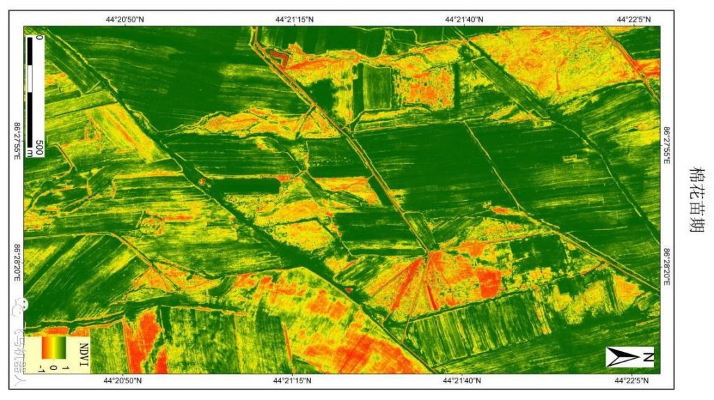
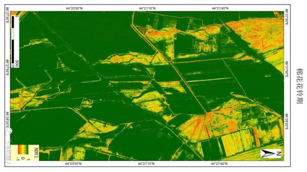
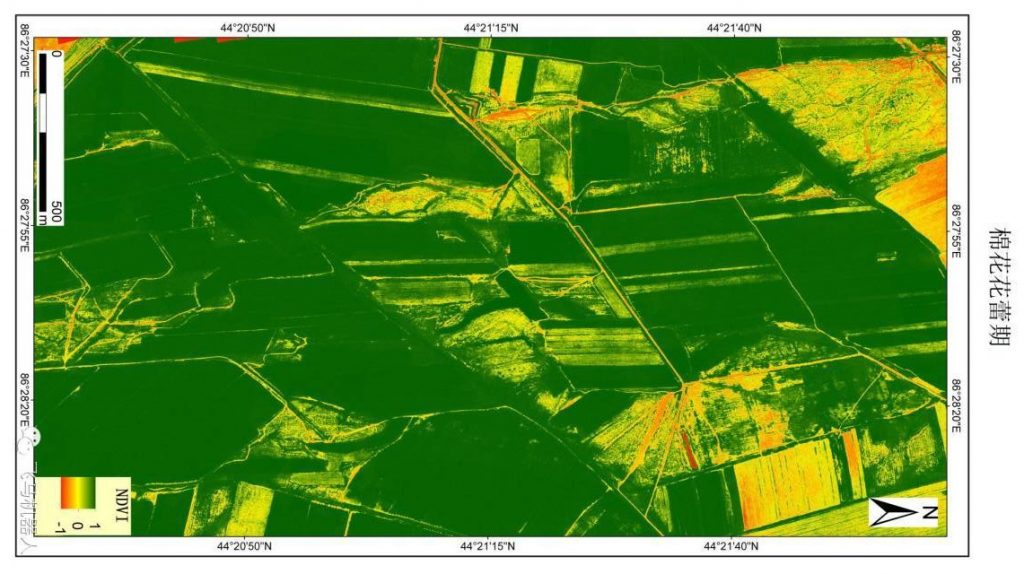
It can be seen from the distribution of vegetation NDVI obtained by infrared data analysis that cotton in the green area grows well, while yellow is relatively poor. This type of map can be used to analyze the growth of crops in large areas, and help researchers to study various problems in crop growth.
Project workflow
- Enter the UAV management line module, determine the scope of the measurement area, set parameters such as overlap degree and ground resolution, and the software automatically generates the route; (You can also use the software to generate route tasks in advance in the internal environment)
- Determine the flight landing and landing point according to the site environment, check the hardware safety and power of the drone, and prepare for flight;
3, the hand throws off, through the ground station system to monitor the entire flight process, to obtain the original image and POS data;
- On-site image quality inspection is completed by the drone housekeeper’s intelligence inspection module, and the quality inspection report and DOM preview map are obtained to ensure that all images are qualified and available;
- Data such as DOM, DSM and 3D model are obtained through data processing software.
In conclusion
Construct a rapid monitoring system for cotton nutrient based on drone platform, and master a new method for real-time and high-efficiency cotton nutrition diagnosis based on UAV remote sensing technology at regional scale. To lay the foundation for remote sensing monitoring of UAVs with efficient nutrient management during cotton planting, and to provide theoretical and technical basis for the implementation of precision agriculture.


You must be logged in to post a comment.