×

Product categories

  • Drone Payload
  • DJI M30 Payload
  • DJI M350 Payload
  • DJI M3T Payload
  • Tethered system
  • Industrial Drone
  • Drone Parachute
  • Drone Gimbal Camera
  • Agriculture Spraying Drone
  • Anti Drone System
  • Drone Accessories
  • VTOL Fixed Wing
  • Underwater Drone
  • Sensor Parts
  • uncategorized

HOW TO SHOP

1 Login or create new account.
2 Review your order.
3 Payment & FREE shipment

If you still have problems, please let us know, by sending an email to info@uavfordrone.com . Thank you!

SHOWROOM HOURS

Mon-Fri 9:00AM - 6:00AM
Sat - 9:00AM-5:00PM
Sundays by appointment only!

SIGN IN YOUR ACCOUNT TO HAVE ACCESS TO DIFFERENT FEATURES

FORGOT YOUR PASSWORD?

FORGOT YOUR DETAILS?

AAH, WAIT, I REMEMBER NOW!
QUESTIONS? CALL: +86 18681572770
  • LOGIN
  • SUPPORT

  • Home
  • About
  • Product
  • Drone Application
  • F.A.Q.
  • Blog
  • Contact
FREEQUOTE
  • Home
  • Mapping Drone
  • Drone UAV mapping for measuring earthwork stockpile volumes
May 19, 2025

Drone UAV mapping for measuring earthwork stockpile volumes

owensong
Friday, 06 September 2019 / Published in Mapping Drone

Drone UAV mapping for measuring earthwork stockpile volumes

This is Drone UAV mapping for measuring earthwork stockpile volumes

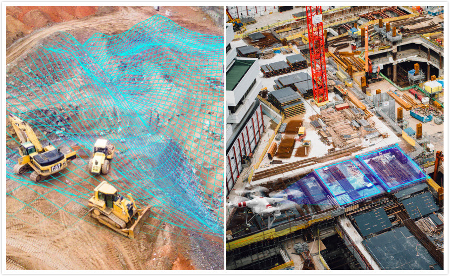
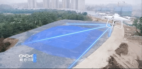
Drone fly to a certain height according to the projects environment and condition,consider both the aerial photo resolution and the range of mapping working efficient . drone fly automatically according to setted route, setting a certain aerial photography overlap rate .drone start to fly and take photos as setted. UAV Mapping precision requirements is 1:500 .Through the drone photo,the terrain is completely covered.

After the drone completed the aerial photography of the projects (earthwork) site,export photos stored in the drone.each photo contains POS information such as longitude and latitude, altitude, shooting attitude (angle) and so on, which is the initial key information.

UAV mapping for measuring earthwork stockpile volumes

Initial data is converted to BIM model

Initial data is converted to BIM model,The REVIT software cannot directly identify photos with POS information such as latitude and longitude, altitude, and shooting attitude (angle). The photo needs to be processed through a “transfer station”. Using professional 3D model software can process photos into point cloud data. The 3D model software such as PHOTOCSAN.Pix4D,ContextCapture.

  1. Align photos, Photoscan will restore the position of each lens according to the latitude, longitude, height and angle of each photo.
  2. Create a dense cloud: Photoscan will calculate the relationship between each point and put each identified point into the intensive calculation.
  3. Generate Grid: With the vector function relationship between the points, Photoscan changes them to connect them according to the actual situation, and builds a 3D model that becomes a dotted line.
  4. Generate texture: Photoscan assigns a flat image to a 3D model based on the data when creating a dense cloud. At this time, the model has an internal structure and an external image, and a preliminary 3D model has been formed.

At this point, the 3D model of the dotted line surface with material overlay has been presented in Photoscan. The software can export files in multiple formats, export Photoscan to point cloud files, and load them into AutoCAD, which can be converted into CAD in 3D view. A line model of elevation properties, that is, a 3-dimensional CAD model with elevation points.

BIM model to get the amount of earthwork.Importing a 3D CAD model into Revit software will generate a model in the 3D view, the “Original terrain model”.

BIM earth and stone calculation technology advantage

In the future,By using the Drone mapping technology, from the measurement of terrain to the calculation of earthwork results, the labor cost and time cost will be greatly reduced. At the same time, the accuracy of the measurement will be much higher than the traditional measurement method.

Working efficiency -UAV measuring earthwork stockpile volumes

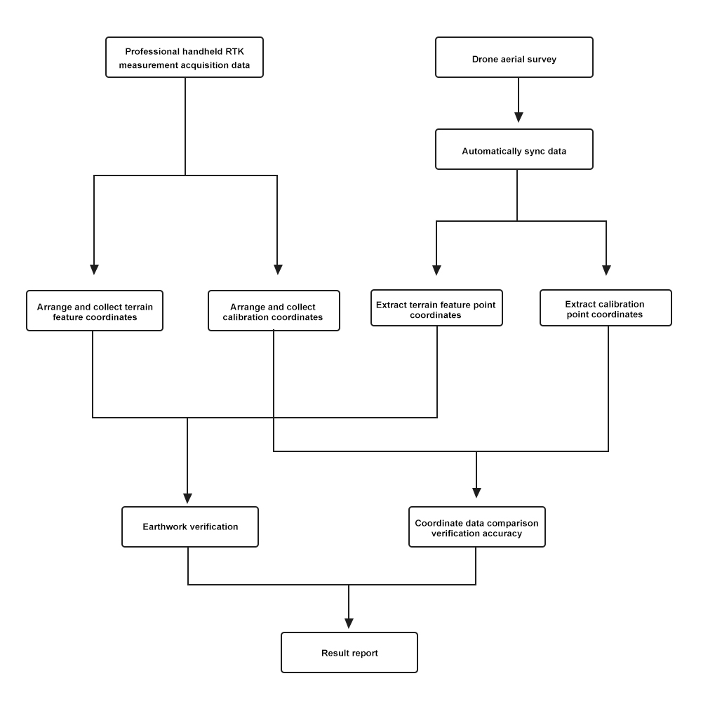
In terms of work efficiency, a 800,000 square meters earthwork measurement accuracy verification process, drone fly 90 minutes, GNSS RTK base photocontrol points working 2 hours,the photo processing (3D software) cost 1 days, compared with the traditional measurement , the cost of drone earthwork stockpile measurement is as low 1/20.

Automated data acquisition and analysis can reduce human error and achieve multiple reuse in a short time. If the earthwork measurement of UAV is applied to earthwork review, it can achieve rapid review to the greatest extent, effectively shortening decision time and project development cycle.If applied to group-level projects and large-scale used, the economic benefits brought about by it will become more significant.
The UAV earthwork measuring solution, companies can achieve efficient, low-cost and recalculable earthwork measurements while ensuring accurate results.

UAV mapping for measuring earthwork stockpile volumes

The UAV measuring stockpile volumes working process

The UAV drone measuring stockpile volumes working process
  • Tweet

What you can read next

Lidar mapping drone UAV-DJI M600 Pro Drone with Lidar scanning

You must be logged in to post a comment.

Categories

  • Drone New
  • Company News
  • Mapping Drone
  • Public Safety drone
  • Technology
  • Uncategorized

Recent Posts

  • DJI M350 drone Multispectral Camera

    DJI M350 drone Multispectral camera river water quality & pollution detection

    1. Project Overview In April 2024, Ramoton Comp...
  • UAV hyperspectral camera

    UAV hyperspectral camera represent an advanced ...
  • DJI M350 drone Laser Methane gas detection Advantage

    In recent years, the application scope of laser...
  • The application of hyperspectral cameras in grading the whiteness of calcium carbonate in open-pit mines.

    The grading detection of calcium carbonate whit...
  • The difference between multispectral camera and hyperspectral camera

    A multispectral camera and a hyperspectral came...

Featured Posts

  • DJI M350 drone Multispectral Camera

    DJI M350 drone Multispectral camera river water quality & pollution detection

    0 comments
  • UAV hyperspectral camera

    0 comments
  • DJI M350 drone Laser Methane gas detection Advantage

    0 comments
  • The application of hyperspectral cameras in grading the whiteness of calcium carbonate in open-pit mines.

    0 comments
  • The difference between multispectral camera and hyperspectral camera

    0 comments

Recent Comments

    Archives

    • December 2024
    • April 2024
    • March 2024
    • December 2023
    • November 2022
    • March 2022
    • February 2022
    • December 2021
    • August 2021
    • June 2021
    • May 2021
    • December 2020
    • November 2020
    • September 2020
    • August 2020
    • June 2020
    • April 2020
    • October 2019
    • September 2019
    • August 2019
    • July 2019
    • June 2019
    • May 2019
    • March 2019

    Meta

    • Log in
    • Entries feed
    • Comments feed
    • WordPress.org

    GET A FREE QUOTE

    Please fill this for and we'll get back to you as soon as possible!

    About Us

    We are a professional enterprise drone, VTOL, drone payload, drone accessories supplier that focuses on drone solution on agricultural , public safety, law enforcement, search rescue, fire fighting ,mapping and surveying.industrial inspection such as power line and gas oil pipe inspection, environmental, air and water condition monitoring, . we supply a full drone solution , one-stop drone solution provider we have worked with many UAVs enterprise, DJI dealer, Police and fire .

    Product Categories

    • Privacy Policy
    • Term & Condition
    • F.A.Q

    GET IN TOUCH

    Call Us now +18681572770 (Direct Call)
    WhatsApp: 8618681572770
    Email: info@uavfordrone.com

    UAVForDrone --Ramoton Tech
    320, Building 2, Pengcheng Zhongjun Compass Industrial Park, Shajing Street, Bao'an District, 518100 Shenzhen, China

    • GET SOCIAL

    Copyright © 2019-2024 UAVforDrone (Ramoton Tech ) All right reserved

    TOP