×

Product categories

  • Drone Payload
  • DJI M30 Payload
  • DJI M350 Payload
  • DJI M3T Payload
  • Tethered system
  • Industrial Drone
  • Drone Parachute
  • Drone Gimbal Camera
  • Agriculture Spraying Drone
  • Anti Drone System
  • Drone Accessories
  • VTOL Fixed Wing
  • Underwater Drone
  • Sensor Parts
  • uncategorized

HOW TO SHOP

1 Login or create new account.
2 Review your order.
3 Payment & FREE shipment

If you still have problems, please let us know, by sending an email to info@uavfordrone.com . Thank you!

SHOWROOM HOURS

Mon-Fri 9:00AM - 6:00AM
Sat - 9:00AM-5:00PM
Sundays by appointment only!

SIGN IN YOUR ACCOUNT TO HAVE ACCESS TO DIFFERENT FEATURES

FORGOT YOUR PASSWORD?

FORGOT YOUR DETAILS?

AAH, WAIT, I REMEMBER NOW!
QUESTIONS? CALL: +86 18681572770
  • LOGIN
  • SUPPORT

  • Home
  • About
  • Product
  • Drone Application
  • F.A.Q.
  • Blog
  • Contact
FREEQUOTE
  • Home
  • Technology
  • Drone Hyperspectral camera sample & application
May 19, 2025

Drone Hyperspectral camera sample & application

owensong
Thursday, 24 June 2021 / Published in Technology

Drone Hyperspectral camera sample & application

This is some of the Hyperspectral camera application that in different fields.

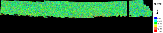
1:Using hyperspectral technology to study the progress of river water quality, selecting a classic model that monitors the concentration and turbidity of suspended solids, using a drone equipped with a hyperspectral camera to obtain river image data in Zhongshan City, and then inverting Zhongshan City based on the classic model The concentration and turbidity of the suspended solids in the river, and the results of the study are of great significance for ensuring the daily life of the residents around the river.

drone Hyperspectral camera water quality monitoring;

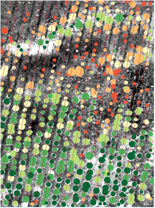
2:Use the Find Rows and Remove Outliers tool to identify crops sorted row by row in an area, and remove weeds, weeds and other foreign objects. Kind Reminder: drone hyperspectral realizes accurate crop positioning and distinguishes the size and health of crops. It is necessary to ensure the spectral accuracy of hyperspectral images and high image resolution.

drone hyperspectral camera crops growing analysis

3:When there is more than one crop, rapid classification and identification is very important, because different crops have different types and amounts of fertilizer. If only fertilizing according to the growth map, some crops may be over-fertilized while others are under-fertilized. Compared with the multi-spectral system, the UAV hyperspectral camera has more spectrum bands and higher spectral resolution, so it can obtain different responses of different crops in different wavelength bands, thereby achieving rapid and effective identification. Its recognition rate can be as high as 95%.

UAV drone hyperspectral camera classification and identification

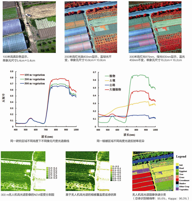
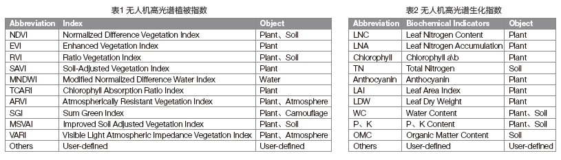
4:Farmers can choose different vegetation indices to reflect crop growth and diseases during the process of acquiring images by the UAV hyperspectral camera. Vegetation indices such as Green Normalized Vegetation Index (GNDVI), Modified Chlorophyll Absorption Index (TCARI), Visible Light Atmospheric Impedance Index (VARI) Ratio Vegetation Index (RVI), Soil Regulated Vegetation Index (OSAVI). Farmers can also choose to directly reflect crop indicators, such as leaf nitrogen, phosphorus and potassium content, chlorophyll content, leaf area index, P content, and K content. Users can also customize the vegetation index for real-time demonstration according to their needs, as shown in Figures 1 and 2.

Drone hyperspectral camera vegetation indices to reflect crop growth and diseases

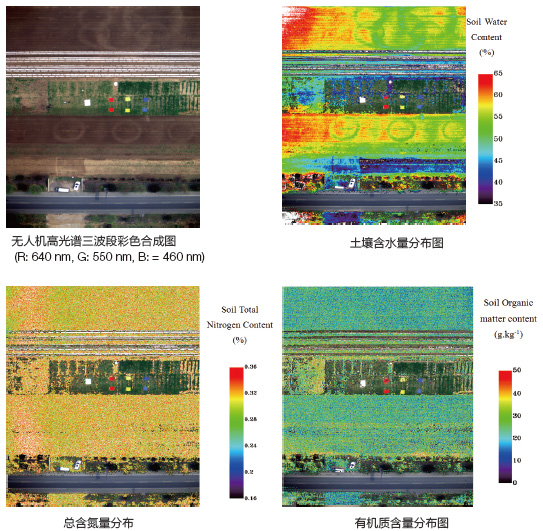
5:The drone hyperspectral camera sensors can obtain the distribution map of soil moisture content, total soil fertility content and organic matter content during its hyperspectral image collection process. According to the soil moisture content and soil fertility distribution map, farmers can irrigate and fertilize quantitatively, thereby solving expenses and avoiding environmental pollution.

The UAV hyperspectral system can obtain the distribution map of soil moisture content, total soil fertility content and organic matter content

6:Analysis of Tobacco Biochemical Index

drone hyperspectral camera sensors Analysis of Tobacco Biochemical Index

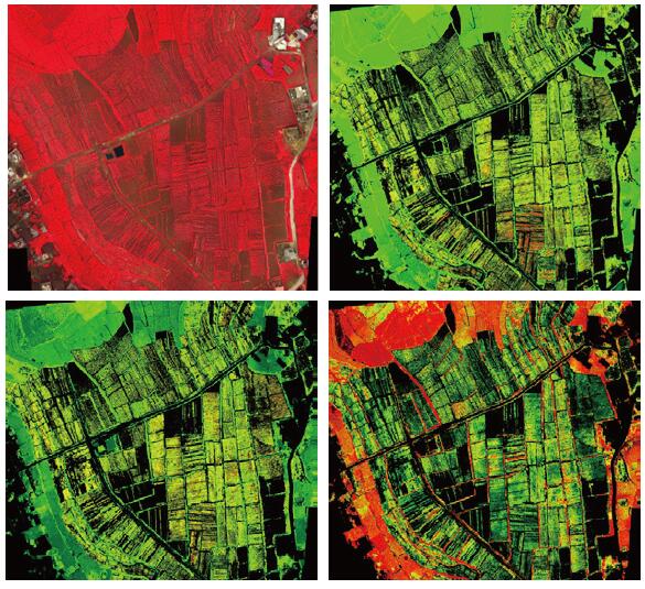
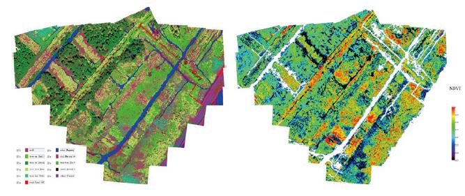
7:Classification of Mangrove Tree Species and NDVI Growth Map

drone hyperspectral camera sensors
Classification of Mangrove Tree Species and NDVI Growth Map

  • Tweet

What you can read next

Different Drone Jammer UAV Blocker Anti-Drone Radio Frequencys Way
UAV Drone Powerline Inspection Solution and Process
Air monitoring drone help quickly to locate odor sources in residential areas

Categories

  • Drone New
  • Company News
  • Mapping Drone
  • Public Safety drone
  • Technology
  • Uncategorized

Recent Posts

  • DJI M350 drone Multispectral Camera

    DJI M350 drone Multispectral camera river water quality & pollution detection

    1. Project Overview In April 2024, Ramoton Comp...
  • UAV hyperspectral camera

    UAV hyperspectral camera represent an advanced ...
  • DJI M350 drone Laser Methane gas detection Advantage

    In recent years, the application scope of laser...
  • The application of hyperspectral cameras in grading the whiteness of calcium carbonate in open-pit mines.

    The grading detection of calcium carbonate whit...
  • The difference between multispectral camera and hyperspectral camera

    A multispectral camera and a hyperspectral came...

Featured Posts

  • DJI M350 drone Multispectral Camera

    DJI M350 drone Multispectral camera river water quality & pollution detection

    0 comments
  • UAV hyperspectral camera

    0 comments
  • DJI M350 drone Laser Methane gas detection Advantage

    0 comments
  • The application of hyperspectral cameras in grading the whiteness of calcium carbonate in open-pit mines.

    0 comments
  • The difference between multispectral camera and hyperspectral camera

    0 comments

Recent Comments

    Archives

    • December 2024
    • April 2024
    • March 2024
    • December 2023
    • November 2022
    • March 2022
    • February 2022
    • December 2021
    • August 2021
    • June 2021
    • May 2021
    • December 2020
    • November 2020
    • September 2020
    • August 2020
    • June 2020
    • April 2020
    • October 2019
    • September 2019
    • August 2019
    • July 2019
    • June 2019
    • May 2019
    • March 2019

    Meta

    • Log in
    • Entries feed
    • Comments feed
    • WordPress.org

    GET A FREE QUOTE

    Please fill this for and we'll get back to you as soon as possible!

    About Us

    We are a professional enterprise drone, VTOL, drone payload, drone accessories supplier that focuses on drone solution on agricultural , public safety, law enforcement, search rescue, fire fighting ,mapping and surveying.industrial inspection such as power line and gas oil pipe inspection, environmental, air and water condition monitoring, . we supply a full drone solution , one-stop drone solution provider we have worked with many UAVs enterprise, DJI dealer, Police and fire .

    Product Categories

    • Privacy Policy
    • Term & Condition
    • F.A.Q

    GET IN TOUCH

    Call Us now +18681572770 (Direct Call)
    WhatsApp: 8618681572770
    Email: info@uavfordrone.com

    UAVForDrone --Ramoton Tech
    320, Building 2, Pengcheng Zhongjun Compass Industrial Park, Shajing Street, Bao'an District, 518100 Shenzhen, China

    • GET SOCIAL

    Copyright © 2019-2024 UAVforDrone (Ramoton Tech ) All right reserved

    TOP